

Environmental Engineering
Faculty of Environmental Engineering
Latest news
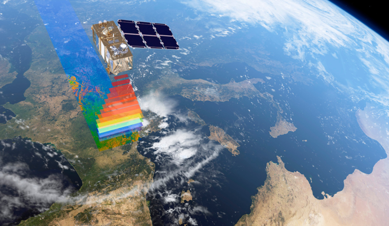
A View Through the Eyes of Satellites: Why Monitoring Earth is Essential
2025-02-04
A View Through the Eyes of Satellites: Why Monitoring Earth is Essential
In today’s world, where we face growing challenges related to climate change, urbanization, and resource management, satellite-based Earth observation has become an indispensable tool. This technology allows us to gather real-time information about our planet without physical contact with observed objects. But how does it work, and how is satellite monitoring used in Lithuania?
How Does Space-Based Monitoring Work?
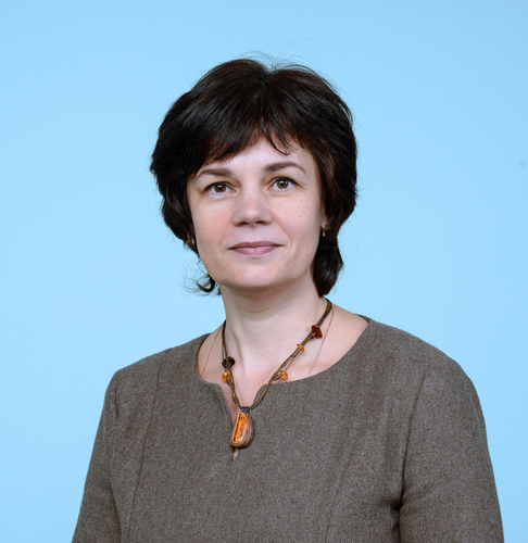
According to Dr. Jūratė Sužiedelytė Visockienė, professor at the Department of Geodesy and Cadastre of VILNIUS TECH’s Faculty of Environmental Engineering, remote sensing can be simply described as satellites orbiting Earth and scanning its surface by detecting various electromagnetic wave reflections. These signals are then processed and analyzed, allowing scientists to view Earth from a new perspective—and even uncover some of its hidden secrets.
There are two main types of remote sensing:
How Does Space-Based Monitoring Work?
According to Dr. Jūratė Sužiedelytė Visockienė, professor at the Department of Geodesy and Cadastre of VILNIUS TECH’s Faculty of Environmental Engineering, remote sensing can be simply described as satellites orbiting Earth and scanning its surface by detecting various electromagnetic wave reflections. These signals are then processed and analyzed, allowing scientists to view Earth from a new perspective—and even uncover some of its hidden secrets.
There are two main types of remote sensing:
- Passive sensors use sunlight as an energy source and capture optical images similar to those taken with a regular camera.
- Active sensors, such as synthetic aperture radar (SAR) systems, emit their own energy and record the reflected signals. This makes it possible to monitor Earth even at night or through cloud cover.
"Currently, there are around 30 space agencies worldwide operating 258 Earth observation satellite missions, with a total of 767 integrated sensors onboard various satellite platforms. This demonstrates the importance and rapid development of this field," explains Dr. Sužiedelytė Visockienė. Some satellites are designed to explore space, while others focus on monitoring Earth. Meanwhile, communication and navigation satellites enable services such as internet access, GPS navigation, and television broadcasting.
What Are Satellites Observing in Lithuania?
In Lithuania, satellites are used to monitor agricultural land, assess crop conditions, and even predict harvest yields. Additionally, they help authorities verify whether farmers are accurately reporting their cultivated land areas.
"In Lithuania, satellite data is used to check whether farmers correctly declare their crop areas, grow the crops they listed in their declarations, and mow their grasslands on time," notes the researcher.
Satellites are also valuable in studying wetland formation in water bodies smaller than 60 hectares. "Wetlands can develop due to agricultural activities—such as plowing too close to water bodies or excessive fertilizer use, which leads to water eutrophication and, eventually, swamp formation. Since current monitoring programs focus on larger lakes and rivers, satellite data helps track smaller bodies of water and determine when intervention is needed. In Lithuania, the process of wetland expansion is quite active, and efforts should be made to slow it down," she explains.
Another major concern in Lithuania is deforestation. Satellite monitoring makes it possible to track forest coverage across the country and helps landowners detect illegal logging on their properties. Additionally, satellites can assess tree health, all in real time.
By analyzing satellite imagery, researchers can classify land use and monitor how landscapes change over time—an essential aspect of environmental management and conservation.

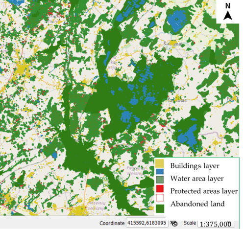
Example: Layered Analysis of Territories
From Hogweed to a Nuclear Power Plant
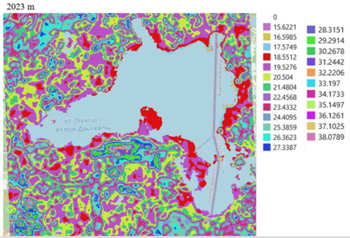
Currently, a team of researchers, led by Dr. Jūratė Sužiedelytė Visockienė, is studying how the closure of the Ignalina Nuclear Power Plant in 2010 has affected the nearby Lake Drūkšiai. This body of water was previously used to cool the plant’s reactors, which resulted in an increase in water temperature along its shores.
"Higher water temperatures significantly disrupt coastal ecosystems, affecting vegetation, flora, and fauna. Our goal is to compare how the plant’s closure has influenced the lake’s ecosystem and whether the water temperature has finally stabilized. Since we have satellite data spanning over two decades, we can compare past and present conditions," explains Professor Sužiedelytė Visockienė, Head of the Department of Geodesy and Cadastre.
However, there is one challenge—the analysis of optical satellite data is hindered by frequent cloud cover, making it difficult to find clear, unobstructed images for accurate comparison.
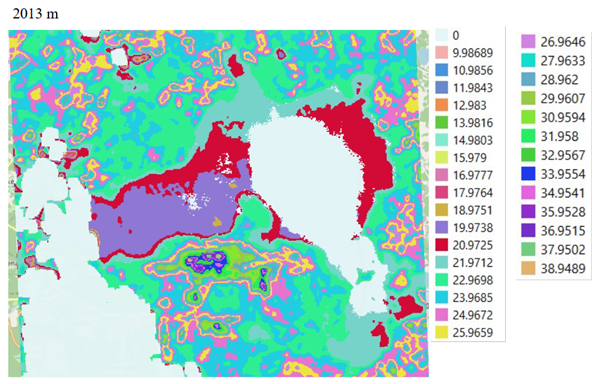
Lake Drūkšiai in 2013

Lake Drūkšiai in 2023
Another Remarkable Study – Mapping the Spread of Giant Hogweed in Lithuania
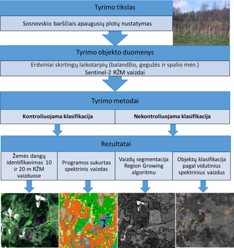
One particularly impressive research project involved creating a map of Giant Hogweed (Heracleum sosnowskyi) distribution in Lithuania. “The spread of Giant Hogweed is a serious problem, so it’s crucial to monitor where these invasive plants are growing and take action. In spring, their leaves have a very distinct bright green color. By identifying the specific electromagnetic wavelength of this shade, we were able to classify the entire territory of Lithuania and determine where Giant Hogweed is present,” explains the researcher.
Another Remarkable Study – Mapping the Spread of Giant Hogweed in Lithuania
One particularly impressive research project involved creating a map of Giant Hogweed (Heracleum sosnowskyi) distribution in Lithuania. “The spread of Giant Hogweed is a serious problem, so it’s crucial to monitor where these invasive plants are growing and take action. In spring, their leaves have a very distinct bright green color. By identifying the specific electromagnetic wavelength of this shade, we were able to classify the entire territory of Lithuania and determine where Giant Hogweed is present,” explains the researcher.
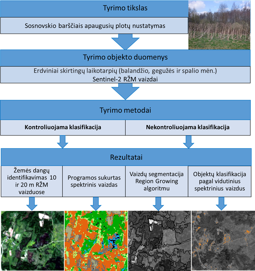
Study on the Spread of Giant Hogweed
Another important aspect of this research was the connection between the spread of this invasive plant and abandoned land. As part of the study, researchers also monitored how the amount of such neglected areas in Lithuania is changing over time.
"Overall, the situation in Lithuania is not too bad—abandoned land makes up only about one percent of the country. However, these areas still present opportunities. They could be left as natural habitats for nesting birds, reforested, or even repurposed for energy needs, such as wind and solar farms," explains Prof. Dr. Jūratė Sužiedelytė Visockienė.
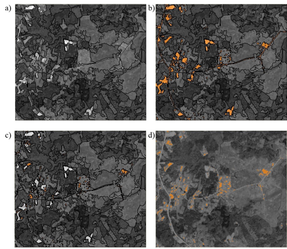
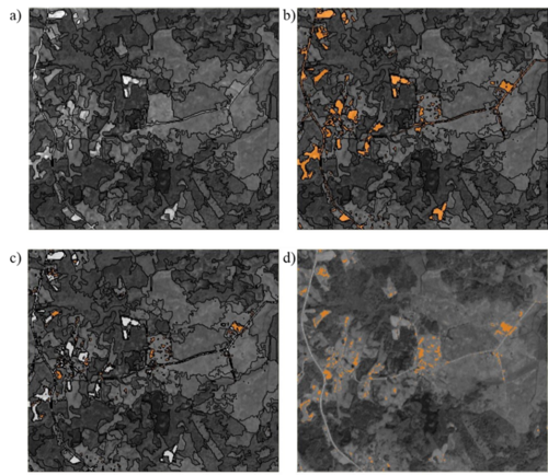
Classification Results: a) Overall segmentation result b) Areas covered with Giant Hogweed, classification value 845.9 (orange color) c) Merged land classes, classification value 950 (gray color) d) Merged objects (Giant Hogweed marked in orange)
And these are just a few examples of what is being monitored in Lithuania. Just like in the rest of the world, satellite data plays a crucial role in ecology and environmental protection—helping to track climate change, air and water pollution, biodiversity shifts, natural disasters and their aftermath, abandoned land, and changes in Earth's surface temperature.
Satellite observations also provide valuable insights into urban development, demographic shifts, and the adoption of new technologies. "This is especially important for implementing sustainable urban planning concepts. Remote sensing is becoming increasingly useful in shaping smart and efficient urban development trends. These technologies allow real-time monitoring of land use changes, temperature variations, elevation levels, air pollution, and the effects of climate change," adds Prof. Dr. Jūratė Sužiedelytė Visockienė from VILNIUS TECH.

-
- Page administrators:
- Laura Ladietaitė
- Karolina Kardokaitė
- Ugnė Daraškevičiūtė
